
Madisonians and visitors can look forward to increased lake access, improved water quality, and enhanced community connection as part of a massive land and shoreline redevelopment along Lake Monona — and plans are progressing as the finer details of project design emerge.
A city update on Thursday that looked at the scope, schedule, and design process for the Madison LakeWay was led by project manager Mike Sturm, a landscape architect for the city of Madison, and project principal Anna Cawrse, a landscape architect and co-director for Denver-based design firm Sasaki.
Sasaki’s plan, formerly known as the Lake Monona Waterfront Master Plan, was approved by the Cityn Council in April of last year. It will transform 1.7 miles of shoreline and 17 acres of land into a more welcoming and environmentally-focused space.
Community feedback is helping refine the project’s schematic design, set to be complete by early next year. Design development will continue through 2026, according to the project timeline, with construction beginning in 2027. Madison Parks is also working with other city agencies to coordinate Madison LakeWay improvements with the John Nolen Drive reconstruction, led by city engineering.
Madison Parks calls the redevelopment “a once-in-a-generation opportunity to shape the future of Madison’s urban waterfront.” The first phase of implementation focuses on proposed shoreline and path features along the John Nolen causeway and 0.6 miles of public lakeshore. Boardwalks, Capitol views, and “living edges” along the shore will give center stage to the visitor experience and natural elements that are functional and ecologically responsible.
Trail transformation
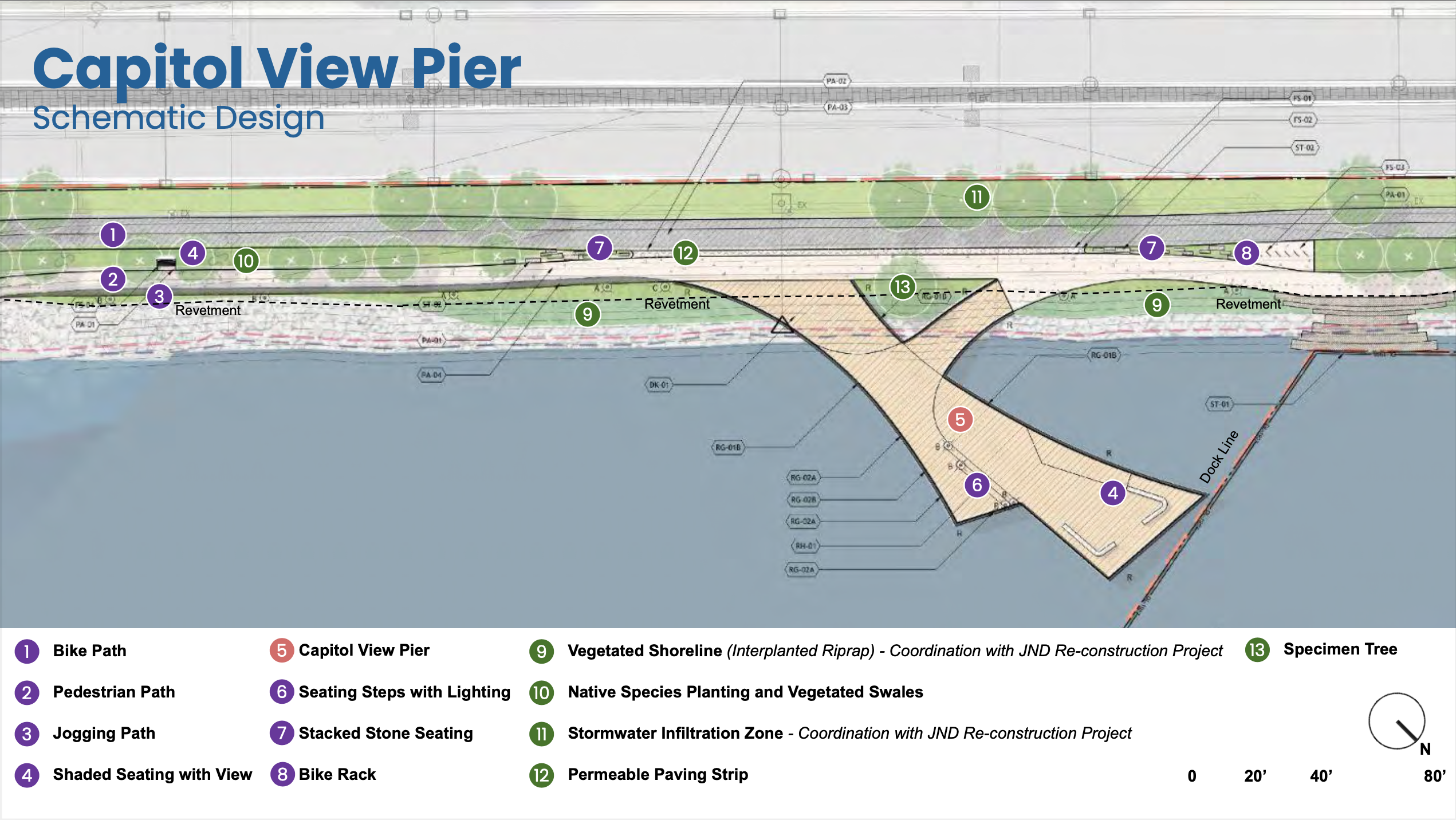
Today, there is a 10-foot-wide multiuse trail spanning 0.5 miles; 1.8 acres of open space without dedicated fishing and resting areas; 30 existing trees, some of which are reportedly in stressed conditions; and stormwater treatment structures within the John Nolen Drive roadway.
The multiuse path, in close proximity to the causeway, can create biker-pedestrian conflict, lacks shade, and is joined by a natural path made over time by joggers, indicating the need for an alternate trail. Concerns over safety and overall usability have pointed to the need for an overhaul that meets recreational needs and insulates the lakeshore from high road traffic.
The new plans will create a half- mile of a 10-foot-wide bike lane, 0.6 miles of a pedestrian path or “story walk” that is six feet wide or more, and 0.3 miles of a separate, two-foot-wide jogging path; 2.5 acres of linear park area, with 13,809 square feet of accessible boardwalk for viewing, fishing, and resting; over 50 trees; and a new stormwater treatment approach that includes vegetated swales, passive canopy tree irrigation, and sediment-reducing inlet structures.
A planting area will create a buffer between car traffic on John Nolen Drive and the bike lane, on the other side of which will run a plaza, stone seating steps, more planting, and a restored lakeshore edge.
“We’re really enhancing the pedestrian experience,” said Cawrse, “[making] a place where people want to walk, want to bike, want to pause.
Avenues and views
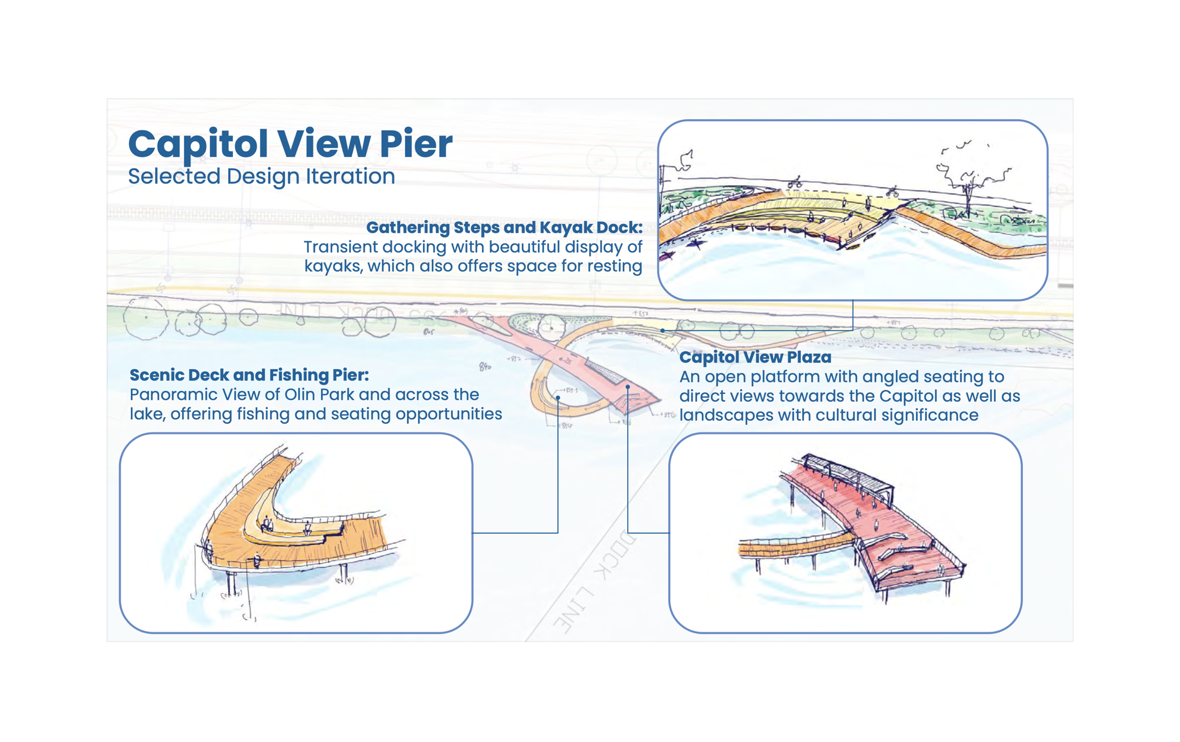
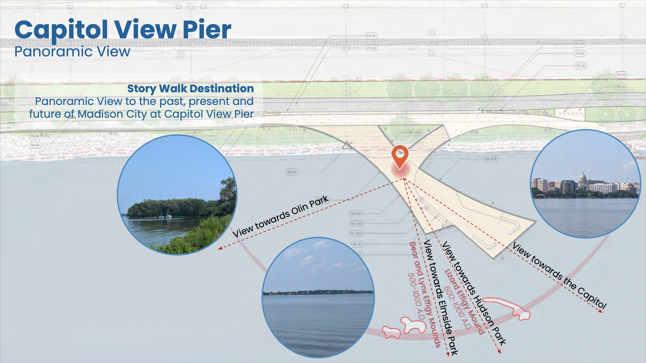
The boardwalks and Capitol view pier and plaza are key study areas for the Madison LakeWay. Public feedback prioritized accessibility and all-season usability.
The boardwalks will run along Lake Monona with shaded resting areas that include native planting, seating and piers. The Capitol view pier and plaza will jut out into Lake Monona with a line of sight to the Capitol building. There will be a scenic deck and fishing pier, with shaded and lighted areas for seating; gathering steps and a kayak docking area.
Natural considerations
Features of the new “living edge” along the Lake Monona shoreline are designed to help return water to the ground and filter pollutants. They include pervious (permeable) paving, an infiltration trench, a bioswale, and water quality structures.
Increasing tree cover to create an urban canopy along the lakeshore will involve preserving current trees wherever possible and selecting new ones based on their appropriateness to the environment — and resilience to conditions like winter salt spray from the roadway.
Ground cover along the Madison LakeWay will vary but will prioritizenative/locally-adapted species with ecological benefits. Considerations for plant maintenance and their ability to survive roadside conditions will also be made, along with safety considerations like plant height and density.
Points of connection
More generally, the Madison LakeWay project aims to create enriching community experiences, emphasizing the area’s culture and history and providing a greater variety of activity options for locals and visitors.
“We’re starting to think about … Lake Monona, and the story we want to tell,” said Cawrse.
There will be public art incorporated at several points within the lakeshore landscape, opportunities for education, increased signage, and expanded usability for year-round events, all efforts to ensure equitable and efficient access to Lake Monona and its plethora of natural attractions.
More to come
Issues such as the potential for increased parking and bike storage demand, the effects of boat traffic on shoreline activities, and more were brought forth during a public Q&A on Thursday, and Sturm said these items will be taken under consideration as Madison LakeWay plans continue to take shape.
He noted that Madison Parks is prepared for an increase in operational responsibilities — such as additional trash and recycling receptacles — and will implement them as needed.